
Visiting Greenwood, British Columbia
BY: BG EDITOR
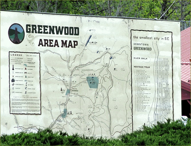
Map at Greenwood Museum & Visitor Center
August , 2016 — GREENWOOD, BC (BG)
Getting Here
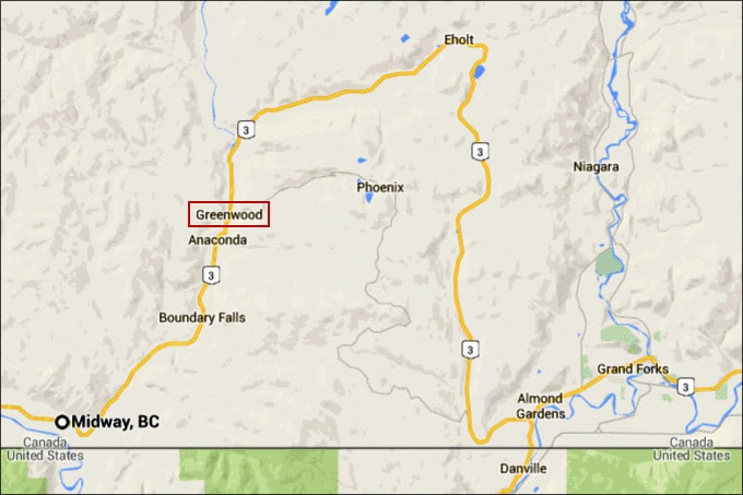
Greenwood is located in south central British Columbia, just 13 kilometers (8 miles) north of the Canada/United States border. We are 80 km (50 mi) east of Osoyoos and 36 km (22 mi) west of Grand Forks.
Heading east from Vancouver and the Lower Mainland, the most direct line of travel to Greenwood is on the Crowsnest Highway. This Interprovincial highway (Highway 3) crosses several mountain passes and valleys en route to Greenwood, and the scenery is gorgeous.
Leaving Hope, the Crowsnest traverses Allison Pass, the Similkameen, and the Okanagan Valley. Heading south through Osoyoos, it then travels east, hugging the Canada/U.S. border (the 'boundary'), crosses over Anarchist Mountain and into the Kootenay-Boundary district. Read more on Highway 3 and driving distances here.
Road conditions during warmer months are excellent, and the drive is very pleasant. Winter tires are recommended on mountain roads from October through April, as road conditions at the higher elevations can be severe. Webcams are positioned at many points along Highway 3 through the entire southern corridor.
THINGS TO DO IN GREENWOOD:
Museum & Visitor Center
Greenwood Community Trails
Take a Walk Around Greenwood
Snow Falling on Cedars Movie Set
Mining Camps, Ruins and Relics
Vehicle Travel
Officially Canada's smallest city, Greenwood is very pedestrian and bicycle-friendly. Shops and eateries, and many local attractions are all within walking distance. Numerous parks and walking trails are also close by. Some historic, mining, nature and recreational sites do require car or wheeled travel. Car rentals are not available in Greenwood. See 'Air Travel' section below for rentals.
Working to become an increasingly ATV-friendly community, Greenwood is surrounded by trails that are enjoyed by four-wheel and all-terrain vehicle drivers, who find many of the rugged backcountry trails well suited for travel. There are hundreds of kilometers of hiking, biking and ATVing trails to explore. Contact the local ATV Club for more information, and see the links above for Greenwood Community Trails and Outdoor Recreation.
Bus and Rail Travel
Greyhound Canada buses provide service between various points along Highway 3, with scheduled stops in Greenwood. There is no passenger rail service to Greenwood.
Air Travel
Regularly scheduled flights from Vancouver and Calgary arrive at several airports close to Greenwood. The largest of these is the Kelowna International Airport (YLW), which offers full-service transport options for shuttle and car rentals.
Regional airports nearby include the Penticton Regional Airport (YYF), and the West Kootenay Regional Airport (YCG) in Castlegar. Car rentals are available at both regional airports.
Driving time from Castlegar to Greenwood is 1 hr. 37 min. Driving time from Penticton to Greenwood is 1 hr. 56 min.
The Grand Forks Municipal Airport (40km/25mi east) has a 1,310m/4,300ft paved runway and provides terminal and fueling facilities for private aircraft.
THINGS TO DO IN GREENWOOD:
Museum & Visitor Center
Greenwood Community Trails
Take a Walk Around Greenwood
Snow Falling on Cedars Movie Set
Mining Camps, Ruins and Relics